About PhotoTrackr - Geotag DSLR
*PhotoTrackr Ver 2.2.5 Release Note. *App Summary - GPS Tracking - 1. Auto-making Tracks - 2. Auto-naming Tracks - 3. Tracking Timer - 4. Tracking Notifications - Record / Edit GPS coordinates - Man
*PhotoTrackr Ver 2.2.5 Release Note.
*App Summary
- GPS Tracking
- 1. Auto-making Tracks
- 2. Auto-naming Tracks
- 3. Tracking Timer
- 4. Tracking Notifications
- Record / Edit GPS coordinates
- Manage GPS records
- View GPS records on Maps
- Draw Route of GPS Records on Maps
- GPX (1.0, 1.1) Export / Import
- Geotag jpg/jpeg files
- 1. Auto Mode - Geotag photos based on comparison of EXIF date and GPS record date.
- 2. Manual Mode - Geotag any photos with one manually entered GPS coordinate.
- View geotagged photos on Maps
- Share photos in Twitter, Goople Plus, Facebook
*Geotag your Digital photos using GPS tracker in your phone!
*Do you have a DSLR camera (or Mirrorless, Digital) without GPS tracker? THIS APP IS EXACTLY WHAT YOU NEED!
*TUTORIAL IS AVAILABLE INSIDE THE APP*
*How-to-Do (Auto Geotagging)
*Main Features
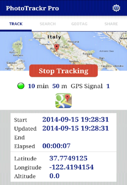
1) GPS Tracking
Above all, make sure your camera clock is in sync with the system time of phone. Check the system time of the phone in settings menu. To make a new track, tap “Start GPS Tracking” and enter a new name. It will start receiving GPS signals. If the location service is turned off, it will ask you to turn it on. You can check the status of GPS tracking in detail such as start time, latitude, longitude, … etc. With this tracking on, take photos with your camera. If you are done taking pictures, tap “Stop Tracking.”
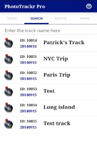
2) Manage GPS Records
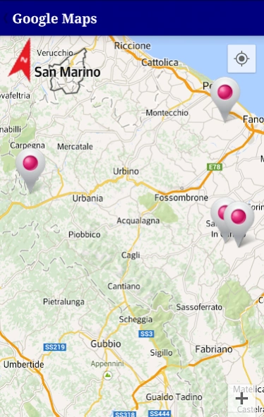
You can see the list of GPS records. You can search for a track by its name. If you tap an item, it will show the track information in detail. If you long-tap an item, a dialog box with 3 items - Google Maps, Export to GPX, Delete - will pop up. Tap Google Maps, it will show the location markers of the track on Google Maps. Tap Export, it will export the record to GPX xml. Tap Delete, it will erase the GPS record.
3) Geotagging
Above all, make sure the geotagging mode is set properly. First, copy photos you want to geotag to your phone.
((Auto Mode)) *IMPORTANT* Geotagging works correctly only for photos taken during the GPS tracking. Second, tap “Select” in order to select a track date. Third, tap “Load” to select photos from your phone. Finally, tap “Start” to geotag your photos based on GPS data you loaded.
((Manual Mode)) Select the GPS location by yourself. You can search the location by address. Then load any photos you want to geotag. Tap “Start” to geotag your photos.
4) Show Geotagged Photos / Share Photos
Load geotagged photos first then tap Google Maps icon to view geotagged photos on the Map. Or you can upload photos to Twitter and G+. You need to authorize the app to get an access to your account.
* Expected Questions
Q1. Do you collect my location data? Where the location data is stored?
A1. No, we do not collect your location data. You don’t need to be concerned about your location privacy at all. It stores GPS locations in your local database of your phone. You can also make log files of GPS tracks if you want (optional), but it also is saved only in your phone. Trust us, we don’t care where you go.
Q2. What if I accidentally forced the app closed while it was receiving GPS signals?
A2. It is okay. By saying it’s okay we mean all of GPS locations are already inserted to your database up to that point. The app inserts GPS locations to your database in real-time when it receives GPS signal. If the app was closed accidentally, you simply don’t know the end time of the track. But it is not used for geotagging your photos anyway. That’s it. So start tracking again.
* Conclusion
We would love to hear from you. If you have any bug reports or suggestions, please contact us. Thank you for downloading the app.
*Designed and Developed by Bjourne Heckman. Copyleft 2014 (c) BjourneApps. All rights unreserved.
Previous Versions
Here you can find the changelog of PhotoTrackr - Geotag DSLR since it was posted on our website on 2016-10-06 13:28:11.
The latest version is 2.2.6 and it was updated on 2024-04-22 10:58:35. See below the changes in each version.
PhotoTrackr - Geotag DSLR version 2.2.6
Updated At: 2015-01-01
Changes: *Photo Tracker Ver 2.2.6 Release Note.,1. ((Beta)) Significant upgrade of showing bitmaps of geotagged photos on Maps -addresses of geotagged photos are shown as well. Up to 3 photos on Maps at the same time. Go to SHARE tab, select geotagged photos, then click Maps icon.,2. Draw Route of GPS Records On Maps (Start, End Point Indicated),3. Minor Bug Fixes,*Designed and Developed by Bjourne Heckman.
Disclaimer
Official Google Play Link
We do not host PhotoTrackr - Geotag DSLR on our servers. We did not scan it for viruses, adware, spyware or other type of malware. This app is hosted by Google and passed their terms and conditions to be listed there. We recommend caution when installing it.
The Google Play link for PhotoTrackr - Geotag DSLR is provided to you by apps112.com without any warranties, representations or guarantees of any kind, so access it at your own risk.
If you have questions regarding this particular app contact the publisher directly. For questions about the functionalities of apps112.com contact us.